
When Every Second Counts: Wireless Emergency Alerts and Mass Notification
By Ken Kehmna, Chief (Ret.) | Senior Operations Advisor, Western Fire Chiefs Association
Always Connected, Always Protected: Wireless Technology and Public Safety – This article is the second of a five-part series examining how wireless technology is transforming public safety. Part 1 covered wearable safety devices. This installment looks at how Wireless Emergency Alerts work and the infrastructure behind some of the largest mass evacuations in recent history.
When a wildfire crowns a ridge and starts racing toward a neighborhood, or a dam shows signs of failure upstream, the single most urgent task for emergency managers is getting a warning to every person in the path of danger: immediately, reliably, and without requiring that anyone be watching the right television channel or checking the right app. Wireless technology has fundamentally transformed this capability, turning every cellular-connected phone into a potential lifeline.
How Wireless Emergency Alerts Work
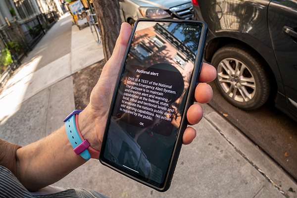
The Wireless Emergency Alert (WEA) system—established by the Warning, Alert, and Response Network (WARN) Act of 2006 and overseen jointly by FEMA and the FCC—is the backbone of public mass notification in the United States. Unlike text messages or push notifications, WEA alerts are broadcast messages transmitted simultaneously to every cell tower in a defined geographic area. Every compatible phone within range receives the message automatically, without requiring the user to opt in, subscribe, or have a data plan. Since 2022, the FCC has mandated that all new mobile phones sold in the U.S. support WEA.
The alerts arrive with a distinctive loud tone and vibration pattern, deliberately designed to cut through noise and sleep. A brief message displays identifying the threat type, the area affected, and any required action. There are several types of emergency alerts:
- National Alerts are a special class of alerts only sent during a national emergency.
- Imminent Threat Alerts include natural or human-made disasters, extreme weather, active shooters, and other threatening emergencies that are current or emerging.
- Public Safety Alerts contain information about a threat that may not be imminent or after an imminent threat has occurred. Public safety alerts are less severe than imminent threat alerts.
- America’s Missing: Broadcast Emergency Response (AMBER) Alerts are urgent bulletins issued in child-abduction cases. An AMBER Alert instantly enables the entire community to assist in the search for and safe recovery of the child.
- Opt-in Test Messages assess the capability of state and local officials to send their WEAs. The message will state that this is a TEST.
In 2024, the system transmitted more than 70,000 WEA messages across the country, covering tornado warnings, wildfire evacuations, tsunami warnings, and flood emergencies.
Geographic Precision and Its Evolution
One of the most significant improvements to the WEA system in recent years has been the introduction of polygon-based geographic targeting. Early WEA messages were delivered to entire counties, which often alarmed people far outside the actual danger zone. Over time, this contributed to what researchers call ‘alert fatigue‘—a well-documented pattern in which people begin ignoring warnings because too many don’t apply to them. Since 2019, the FCC has required that alerts be targeted to the specific geographic shape of the threatened area rather than the enclosing county, improving precision to within a tenth of a mile in many cases.
This matters enormously in evacuation scenarios. During the 2024 wildfire season in California, precisely targeted WEA messages directed residents of specific neighborhoods to evacuate while allowing adjacent areas to shelter in place. Doing so reduced dangerous traffic congestion on evacuation routes and helped emergency managers direct resources more efficiently. The same precision allowed authorities during Hurricane Helene to send different messages to coastal residents (mandatory evacuation) and inland residents (shelter in place) within the same county, over the same cellular infrastructure, simultaneously.
The difference between a county-wide alert and a polygon-targeted alert can mean the difference between a manageable evacuation and gridlock that kills people. — FEMA Integrated Public Alert and Warning System Report, 2023
Evacuation Warnings in Real Disasters
The real-world scale of WEA-driven evacuations is striking. During Hurricane Milton in October 2024, wireless emergency alerts triggered an estimated 6 million evacuations in Florida alone—one of the largest peacetime mass movements in American history. The effort was coordinated in large part through cellular broadcasts. The 2023 Maui wildfires brought the WEA system into sharp focus in a different way. The tragedy prompted extensive after-action reviews of how and when alerting tools are deployed. It drove a nationwide conversation among emergency managers about alert timing, decision-making under rapidly evolving conditions, and the weight of responsibility that comes with controlling the system. Officials across the country have since pointed to that event as a catalyst for strengthening alerting protocols and ensuring that the tools available are as well understood as they are well-maintained.
For wildfires in particular, the speed of WEA is critical. In leading wildfire states, fire perimeter mapping is integrated directly with alerting infrastructure. As a fire boundary expands—tracked via satellite, aerial observation, and ground crews—evacuation zones can be issued and updated in near real time. Residents who moved into a zone after an initial alert was sent still receive the warning when their phone connects to a newly designated alert area, a feature known as “cell broadcast” that ensures even late arrivals get the message.
IPAWS: The System Behind the System
The WEA network is one component of a larger federal architecture called IPAWS, the Integrated Public Alert and Warning System. IPAWS aggregates multiple alerting channels: WEA to cell phones, the Emergency Alert System (EAS) which interrupts radio and television broadcasts, NOAA Weather Radio, and digital signage systems in airports and transit hubs. When a local emergency manager, such as a county sheriff, a state emergency management director, or a federal agency, sends an alert through IPAWS, it simultaneously broadcasts across all of these channels. It ensures redundancy across different media and different audiences.
This matters because different populations depend on different information channels. Older adults may not carry a smartphone but have a radio on. Visitors from other countries may have phones that don’t receive domestic WEA messages. Hearing-impaired individuals may not register the WEA tone. IPAWS is designed around the principle that no single channel reaches everyone. The goal is saturation.
Keeping the Network Up When It Matters Most
The events of recent years, including hurricanes, wildfires, floods, and tornadoes, have stress-tested wireless infrastructure in ways that reveal both its extraordinary capability and its vulnerabilities. When towers go down and fiber lines are severed, the entire edifice of connected public safety can collapse. The industry’s response has been to build redundancy into the network itself.
Deployable cellular systems, including Cells on Wheels (COWs) and Cells on Light Trucks (COLTs), can be rapidly transported to disaster zones to restore coverage within hours. During Hurricane Helene in 2024, AT&T and Verizon deployed dozens of such units to western North Carolina after the storm destroyed large sections of the terrestrial network, restoring enough connectivity for emergency managers to resume issuing evacuation orders and coordinating search and rescue operations.
Low Earth orbit (LEO) satellite constellations, particularly Starlink, have also become important public safety tools in disaster scenarios. Emergency managers in multiple recent hurricanes used Starlink terminals to restore communication in communities where all other connectivity had been lost. SpaceX has also begun testing direct-to-cell satellite capability, which would allow standard smartphones to receive messages, including emergency alerts, via satellite even when no towers are in range, a development that could close one of the most persistent gaps in the emergency alerting infrastructure.
Getting an alert out is one thing. Knowing exactly who needs to move, where they should go, and in what order is another challenge entirely. That is where the next generation of tools comes in.
Every polygon drawn on a map, every evacuation order issued, every life-saving minute saved—all of it travels on a cellular signal. Lose the signal, and the warning never arrives.
About the Author: Ken Kehmna is a retired Fire Chief and Senior Operations Advisor for the Western Fire Chiefs Association (WFCA). He also serves as a key advisor to Public Safety Towers Company, bringing more than three decades of public safety leadership experience to PSTC’s mission of strengthening emergency communications infrastructure across communities.
Next in the series: getting an alert out is one thing. Knowing exactly who needs to move, where they should go, and in what order is another challenge entirely. Part 3 looks at the zone-based evacuation software that helped emergency managers track 57 active evacuation zones simultaneously during the 2025 LA wildfires.